Research · working paper
The hard questions, answered.
26 questions people ask us about ARIADNE, each with a short answer from our own research and code. Every answer is marked with how far it has been proven, because an honest “not yet” is worth more than a confident guess.
- Authors
- Team Wavsy, Sofia
- Version
- 21 November 2026
- Scope
- Reflective fiber, in sunlight
Abstract
Fiber-optic FPV drones cannot be jammed and give no radio signal, but they leave their fiber on the ground, and one end of it is the launch point. ARIADNE is software for a patrol drone that detects an incoming drone, reports it to a base, and follows the fresh fiber by its sun glint to a launch zone that a person confirms. The method answers the two reasons manual tracing failed: it knows which cable is new because it starts from the drone it just saw, and it finds the glint by calculation instead of luck. The full mission runs in simulation; real-fiber field tests are the next step.
How to read the marks
- Built and testedReal code with tests behind it.
- SimulationMeasured, but in our simulation only.
- PlannedDesigned, not built or not measured yet.
- Open questionWe do not have an answer yet.
1
The question
Everything on this site is an answer to one question.
- 1.1How do we find the operator?Simulation
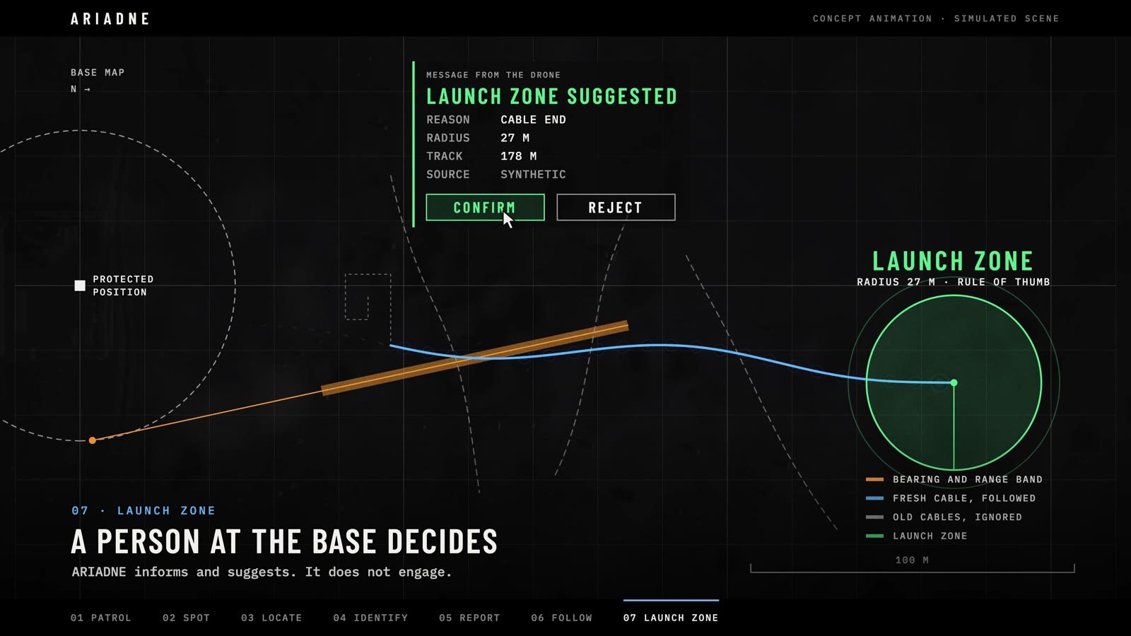
- We follow the fresh fiber to where it ends. That end is the launch point, and we report it as a zone with a radius. The operator is usually near it, not at it, and moves, so we say launch zone and a person at the base decides what it means.
- 1.2Has this been done before?Built and tested
- By hand, yes: a Ukrainian brigade followed glinting fiber to a launch crew in February 2025. What we found no public description of is starting the trace from a drone that was just detected, and tilting the camera to a computed glint angle.
2
Seeing the drone
How far away the patrol drone notices an incoming drone, and what it can say about it.
- 2.1How far away can it detect a drone?Simulation
- With the assumed 4K camera and a 70° lens, a 0.4 m drone is 6 pixels wide at about 180 m, which is the smallest box we report. In simulation the first report came at a median of 137 m (92 to 168 m), about 12 seconds before the drone would reach the base.
- 2.2At what distance can it tell that it is a drone?Built and tested
- At that same range, once the box is at least 6 pixels wide and appears in 3 of the last 5 frames. Six pixels support “something is there”. We have not yet measured the real detector’s hit rate against size.
- 2.3At what distance can it tell what kind of drone it is?Planned
- Not established yet. The classifier that looks for the fiber spool is the next thing we build, and the spool is only a few pixels across at detection range. Nothing yet shows it can be recognised that far out.
- 2.4How does it measure the distance to the drone?Built and tested
- From how wide the drone looks in the picture, assuming it is between 0.25 m and 0.60 m across. That gives a distance good to about ±40%, which is why the map shows a band and not a dot. The direction comes from where the drone sits in the frame, and it is good.
- 2.5How does it tell a bird from a drone?Built and tested
- On both the image and the movement. The detector judges the picture, then a sighting only counts if it shows up in 3 of the last 5 frames without jumping more than 80 pixels, because a drone stays in view and moves smoothly. We have not yet measured the false-alarm rate with birds.
3
Seeing the fiber
The fiber is about a quarter of a millimetre thick. Seeing it from the air is the heart of the project.
- 3.1How does it detect a reflective fiber-optic cable?Built and tested
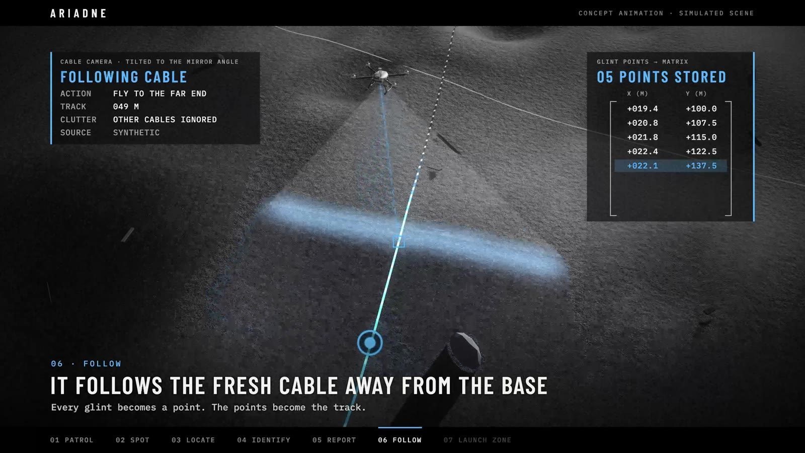
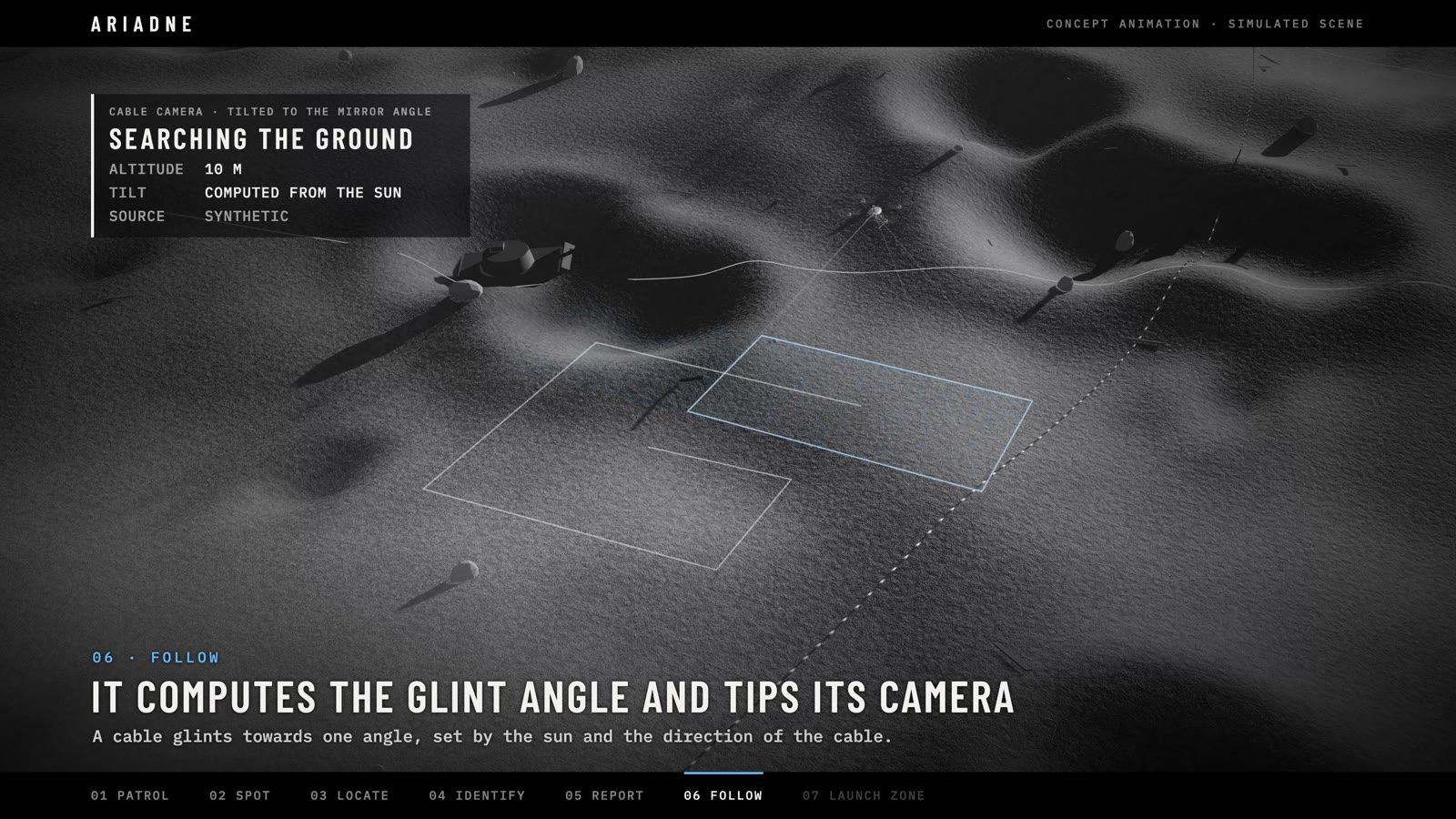
- By its glint in sunlight, with an ordinary colour camera. The drone works out the one angle from which the cable reflects the sun, tips its camera to it from 10 m up, and turns the thin bright line in the picture into points on the ground.
- 3.2Has that been proven on real fiber?Planned
- Not yet. The detector and follower are tested on synthetic pictures only. Filming a real line on grass at 2, 5 and 10 metres, in sun and in shade, is the next test.
- 3.3How does it detect a matte, non-reflective cable?Planned
- Today it does not: matte fiber gives no glint and ARIADNE finds nothing. The plan is near-infrared lighting on the drone with a matched camera, so the drone lights the fiber itself. The first step is a bench test at 1, 3 and 10 metres.
- 3.4What happens at night, under cloud or in rain?Simulation
- No direct sun means no glint. After sunset the drone still reports the incoming drone, says that the cable cannot be traced, and stays on patrol. Overcast and rain are not modelled, so we assume it does not work.
4
Too many cables
A used field is crossed by old fiber. This is where following cables by hand stopped working.
- 4.1What happens in a field covered with fiber-optic cables?Simulation
- It never searches for cable in general. It starts where it just saw the drone, accepts only a cable that runs along the drone’s approach, and at every crossing keeps to the straighter line. With seven old cables in simulation it reported a zone in 20 of 20 missions; 16 contained the true launch point, with a median error of 23.8 m.
- 4.2And in a forest or in bushes?Open question
- Not modelled. Our simulated ground is flat and open. Stretches of up to 80 m where the cable cannot be seen are bridged and reported as such; a longer dark stretch looks like the end of the cable.
- 4.3Both sides fly fiber drones. How does it know an enemy cable from a friendly one?Open question
- It does not classify cables by side. The cable it follows is the one behind a drone it just watched fly at the protected position, traced away from the base, and a person confirms every zone. Telling the two sides’ cables apart by any other means is an open question.
- 4.4How does it tell an active cable from an old one?Built and tested
- Not from the picture: old and new fiber look the same, and a live fiber does not glow in any way a camera can see. A cable is “active” for us because we just watched the drone lay it. Freshness comes from the sighting.
5
Models and metrics
Two different kinds of software do the seeing, and they are scored in different ways.
- 5.1Which model recognises the drone?Built and tested
- A YOLO11s detector, run on the drone. Each frame is checked twice: once whole at 640 pixels, and once as a full-resolution tile that locks on to the last sighting. We chose it because it was the only candidate its author had scored on a separate public benchmark.
- 5.2Which metrics do we use for the drone model?Built and tested
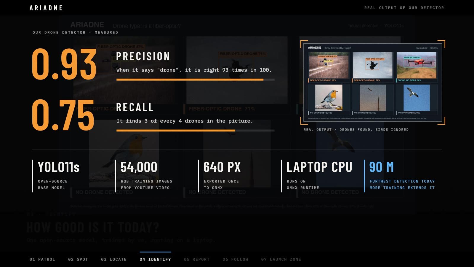
- Precision, recall and false alarms per minute, counting a hit when the predicted box overlaps the true one by at least 0.3, because small drones need a forgiving threshold. F1 follows from the first two. Boxes with a confidence score under 0.25 are dropped.
- 5.3What are the drone model’s scores?Planned
- We have no scores of our own yet. The scoring tool is built and the air-to-air test video is prepared; running it is next. The model’s author reports precision 0.93 and recall 0.76 on a public benchmark, and we expect less from a camera that is itself flying.
- 5.4Which model recognises the cable?Built and tested
- Not a neural network. It is classical image processing in five steps: keep what is white, keep what is thin, drop the specks, find straight runs, refit the line. We found no public labelled dataset of fiber on the ground to train a network on.
- 5.5Which metrics do we use for the cable model?Simulation
- The outcome of the whole trace: was a zone reported, is the true launch point inside it, how many metres off is its centre, how many metres were bridged without seeing the cable, and how many other cables were ignored on the way.
6
Data
What the drone sends, and where it is kept.
- 6.1What data does the drone send?Built and tested
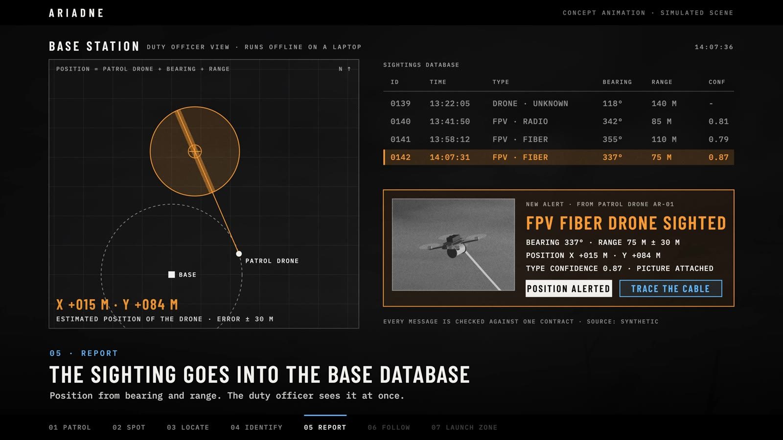
- Small messages of three kinds: a drone sighting, a cable track and a launch zone. Each carries a time, a position with its error, and a label saying whether it is simulated, recorded or live. With a sighting it sends a cropped picture, never the full video.
- 6.2What database does it go into?Built and tested
- Today a journal file on the base laptop. Every accepted report and every confirm or reject is appended as one line, and the file only grows. The format is GeoJSON, an open standard that map systems and databases already read.
- 6.3Is the data shared between drones and units?Planned
- Not yet. One drone reports to one base. Exporting confirmed zones to the map systems units already use is planned, and a shared record of traced cables and launch sites across drones is where we want to take it.
7
Limits
What the concept itself cannot do, whatever the software.
- 7.1Will the patrol drone survive the flight?Open question
- That is a real limit. Following a cable means flying low and slow towards the launch site. The one documented trace by hand ended six kilometres behind the line. We do not claim to have solved it.
- 7.2What can an opponent do about it?Open question
- Use matte fiber, lay decoy cable, launch from a ground robot, or cut the fiber at the launch point after every flight. We name these because a counter-measure that hides its weak points is not one you can plan around.
- 7.3Does it act on what it finds?Built and tested
- No. ARIADNE informs and suggests. It takes no action on a zone, and only a person at the base can confirm one.
8
Tables
All figures below describe the simulation: synthetic ground, a modelled glint, a simulated detector that misses and raises false boxes, and a drifting position error. They say nothing yet about real footage.
Table 1. Detection range and the forward camera
| Camera | 0.4 m drone is 6 px at | First report, median | Drone reported | Zone sent |
|---|---|---|---|---|
| 1080p, 70° lens | about 90 m | 62 m (44–79 m) | 18 of 20 | 17 of 20 |
| 4K, 70° lens (chosen) | about 180 m | 137 m (92–168 m) | 20 of 20 | 20 of 20 |
Twenty simulated missions in good light. With the 4K camera the incoming drone is about 210 m from the base at the first report: roughly 12 seconds of warning at 18 m/s.
Table 2. Tracing the cable, twenty missions per scenario
| Scenario | Zone reported | True point inside | Zone wrong | Median error | Worst error |
|---|---|---|---|---|---|
| Good light | 20 | 20 | 0 | 2.7 m | 5.6 m |
| Seven old cables | 20 | 16 | 4 | 23.8 m | 37.4 m |
| 60 m of cable in shade | 20 | 20 | 0 | 2.3 m | 5.3 m |
| Sun along the cable | 20 | 20 | 0 | 1.5 m | 7.4 m |
| Radio drone, no cable | 0 | n/a | 0 | n/a | n/a |
| After sunset | 0 | n/a | 0 | n/a | n/a |
In all 120 missions the incoming drone was reported. The two scenarios with no zone end that way on purpose: a radio drone leaves no cable, and after sunset there is no glint to follow.
Have a harder question? We want to hear it.